


La Cluse

cailloux54
User
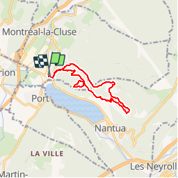

Length
11.6 km

Max alt
903 m

Uphill gradient
563 m
Km-Effort
19.1 km

Min alt
481 m

Downhill gradient
562 m
Boucle
Yes
Creation date :
2014-12-10 00:00:00.0
Updated on :
2014-12-10 00:00:00.0
4h04
Difficulty : Medium

FREE GPS app for hiking
 SityTrail
IGN / Geographical institutes
SityTrail Plus
The world is yours!
About
Trail Walking of 11.6 km to be discovered at Auvergne-Rhône-Alpes, Ain, Montréal-la-Cluse. This trail is proposed by cailloux54.
Description
vue sur Nantua

Positioning
Country:
France
Region :
Auvergne-Rhône-Alpes
Department/Province :
Ain
Municipality :
Montréal-la-Cluse
Location:
Unknown
Start:(Dec)
Start:(UTM)
698784 ; 5116355 (31T) N.
Comments