


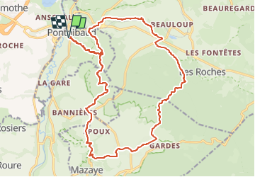
Pontgibaud petit Chambois pontgibaud 22 km

jeanic63
User

Length
22 km

Max alt
848 m

Uphill gradient
395 m
Km-Effort
28 km

Min alt
669 m

Downhill gradient
396 m
Boucle
Yes
Creation date :
2023-05-14 07:47:20.296
Updated on :
2023-05-14 07:56:58.458
6h15
Difficulty : Medium

FREE GPS app for hiking
 SityTrail
IGN / Geographical institutes
SityTrail Plus
The world is yours!
About
Trail On foot of 22 km to be discovered at Auvergne-Rhône-Alpes, Puy-de-Dôme, Pontgibaud. This trail is proposed by jeanic63.
Description
départ place de Pontgibaud
Positioning
Country:
France
Region :
Auvergne-Rhône-Alpes
Department/Province :
Puy-de-Dôme
Municipality :
Pontgibaud
Location:
Unknown
Start:(Dec)
Start:(UTM)
488397 ; 5075266 (31T) N.
Comments