


Rando May sur Orne 43 km

argonautes
User
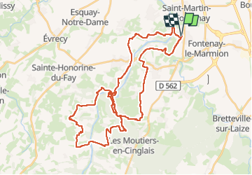

Length
43 km

Max alt
138 m

Uphill gradient
751 m
Km-Effort
54 km

Min alt
6 m

Downhill gradient
752 m
Boucle
Yes
Creation date :
2023-05-14 06:27:43.881
Updated on :
2023-05-14 09:50:57.507
2h58
Difficulty : Difficult

FREE GPS app for hiking
 SityTrail
IGN / Geographical institutes
SityTrail Plus
The world is yours!
About
Trail Mountain bike of 43 km to be discovered at Normandy, Calvados, May-sur-Orne. This trail is proposed by argonautes.
Positioning
Country:
France
Region :
Normandy
Department/Province :
Calvados
Municipality :
May-sur-Orne
Location:
Unknown
Start:(Dec)
Start:(UTM)
691454 ; 5442051 (30U) N.
Comments