


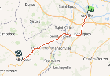
5-Auvillar-Miradoux 18km

thonyc
User GUIDE

Length
17.7 km

Max alt
220 m

Uphill gradient
421 m
Km-Effort
23 km

Min alt
64 m

Downhill gradient
332 m
Boucle
No
Creation date :
2023-05-14 07:14:45.085
Updated on :
2023-05-18 15:11:28.614
5h13
Difficulty : Medium

FREE GPS app for hiking
 SityTrail
IGN / Geographical institutes
SityTrail Plus
The world is yours!
About
Trail Walking of 17.7 km to be discovered at Occitania, Tarn-et-Garonne, Auvillar. This trail is proposed by thonyc.
Positioning
Country:
France
Region :
Occitania
Department/Province :
Tarn-et-Garonne
Municipality :
Auvillar
Location:
Unknown
Start:(Dec)
Start:(UTM)
331806 ; 4881806 (31T) N.
Comments