


la sierre -la moucherotte

maupassant38
User
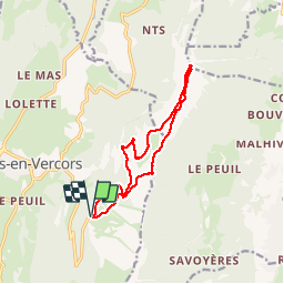

Length
11.9 km

Max alt
1886 m

Uphill gradient
677 m
Km-Effort
21 km

Min alt
1375 m

Downhill gradient
676 m
Boucle
Yes
Creation date :
2019-02-22 22:31:47.468
Updated on :
2019-02-22 22:31:47.485
3h22
Difficulty : Medium

FREE GPS app for hiking
 SityTrail
IGN / Geographical institutes
SityTrail Plus
The world is yours!
About
Trail Walking of 11.9 km to be discovered at Auvergne-Rhône-Alpes, Isère, Lans-en-Vercors. This trail is proposed by maupassant38.
Positioning
Country:
France
Region :
Auvergne-Rhône-Alpes
Department/Province :
Isère
Municipality :
Lans-en-Vercors
Location:
Unknown
Start:(Dec)
Start:(UTM)
705207 ; 4999165 (31T) N.
Comments