


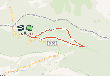
Saou-Pas de Lauzens-Drôme

ThierryJ01
User


1h52
Difficulty : Medium

FREE GPS app for hiking
 SityTrail
IGN / Geographical institutes
SityTrail Plus
The world is yours!
About
Trail Walking of 6.3 km to be discovered at Auvergne-Rhône-Alpes, Drôme, Saou. This trail is proposed by ThierryJ01.
Description
Rando facile, voir douce, familiale. Se garer a la bergerie Paturel. arrivée au parking de la prade, le retour par chemin de la prade.
Sur le parcours passage sur du sable poudreux blanc tres fin anciennement utilisé pour la porcelaine. Belle vue sur une partie du sinclinal, Pas du Faucon, Gds Pomerolle.
Positioning
Comments