


levens Sainte Claire

PEBREJOSIANE
User
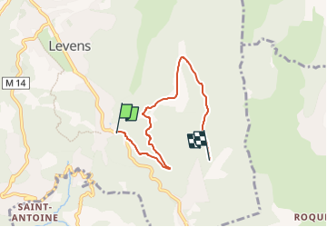

Length
5.2 km

Max alt
773 m

Uphill gradient
256 m
Km-Effort
8.2 km

Min alt
513 m

Downhill gradient
143 m
Boucle
No
Creation date :
2023-05-17 04:36:23.211
Updated on :
2023-05-17 04:36:24.249
1h30
Difficulty : Easy

FREE GPS app for hiking
 SityTrail
IGN / Geographical institutes
SityTrail Plus
The world is yours!
About
Trail Nordic walking of 5.2 km to be discovered at Provence-Alpes-Côte d'Azur, Maritime Alps, Levens. This trail is proposed by PEBREJOSIANE.
Description
MN
Positioning
Country:
France
Region :
Provence-Alpes-Côte d'Azur
Department/Province :
Maritime Alps
Municipality :
Levens
Location:
Unknown
Start:(Dec)
Start:(UTM)
359233 ; 4855120 (32T) N.
Comments