


caen gavrus

memeche
User
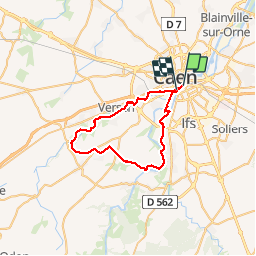

Length
39 km

Max alt
112 m

Uphill gradient
426 m
Km-Effort
45 km

Min alt
0 m

Downhill gradient
430 m
Boucle
No
Creation date :
2014-12-10 00:00:00.0
Updated on :
2014-12-10 00:00:00.0
3h08
Difficulty : Medium

FREE GPS app for hiking
 SityTrail
IGN / Geographical institutes
SityTrail Plus
The world is yours!
About
Trail Other activity of 39 km to be discovered at Normandy, Calvados, Caen. This trail is proposed by memeche.
Description
Remontez de la vallée de l'odon. Retour par la vallée de l'orne. Trajet varié et sympa
Positioning
Country:
France
Region :
Normandy
Department/Province :
Calvados
Municipality :
Caen
Location:
Unknown
Start:(Dec)
Start:(UTM)
692541 ; 5450198 (30U) N.
Comments