


GR470 Version appli

gdela
User
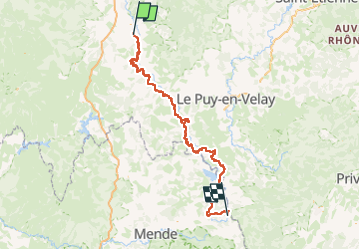

Length
194 km

Max alt
1502 m

Uphill gradient
6078 m
Km-Effort
273 km

Min alt
424 m

Downhill gradient
5492 m
Boucle
No
Creation date :
2023-05-19 14:31:45.908
Updated on :
2023-05-19 14:36:13.73
61h58
Difficulty : Difficult

FREE GPS app for hiking
 SityTrail
IGN / Geographical institutes
SityTrail Plus
The world is yours!
About
Trail Walking of 194 km to be discovered at Auvergne-Rhône-Alpes, Haute-Loire, Brioude. This trail is proposed by gdela.
Positioning
Country:
France
Region :
Auvergne-Rhône-Alpes
Department/Province :
Haute-Loire
Municipality :
Brioude
Location:
Unknown
Start:(Dec)
Start:(UTM)
529668 ; 5016368 (31T) N.
Comments