


Bélissier

Patricelecerf
User
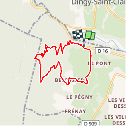

Length
8.5 km

Max alt
1101 m

Uphill gradient
563 m
Km-Effort
16 km

Min alt
529 m

Downhill gradient
566 m
Boucle
Yes
Creation date :
2017-08-14 00:00:00.0
Updated on :
2017-08-14 00:00:00.0
2h43
Difficulty : Easy

FREE GPS app for hiking
 SityTrail
IGN / Geographical institutes
SityTrail Plus
The world is yours!
About
Trail Walking of 8.5 km to be discovered at Auvergne-Rhône-Alpes, Upper Savoy, Alex. This trail is proposed by Patricelecerf.
Description
31.11.14 petite ballade facile mais à faire par beau temps. gps indispensable car pas tracé ni repère
Physique 1
Technique 2
Positioning
Country:
France
Region :
Auvergne-Rhône-Alpes
Department/Province :
Upper Savoy
Municipality :
Alex
Location:
Unknown
Start:(Dec)
Start:(UTM)
284085 ; 5086515 (32T) N.
Comments