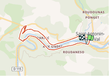
Saint Antonin Noble Val - côte de Ouf et cirque de Baune

PhilB24
User


2h52
Difficulty : Difficult

FREE GPS app for hiking
 SityTrail
IGN / Geographical institutes
SityTrail Plus
The world is yours!
About
Trail Walking of 9 km to be discovered at Occitania, Tarn-et-Garonne, Saint-Antonin-Noble-Val. This trail is proposed by PhilB24.
Description
rando au départ de Saint Antonin. Montée raide au pied de la falaise. Des câbles en pied de falaise peuvent aider pour la progression. à éviter en cas de sol glissant. Dans la descente cohabitaytion possible avec VTT.
Photos


Positioning
Comments