


2023 05 ARBONNE T2

michel1025
User
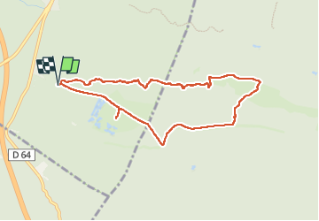

Length
7.9 km

Max alt
130 m

Uphill gradient
96 m
Km-Effort
9.1 km

Min alt
73 m

Downhill gradient
96 m
Boucle
Yes
Creation date :
2023-05-04 11:36:44.0
Updated on :
2023-05-19 18:13:56.768
2h29
Difficulty : Medium

FREE GPS app for hiking
 SityTrail
IGN / Geographical institutes
SityTrail Plus
The world is yours!
About
Trail Walking of 7.9 km to be discovered at Ile-de-France, Seine-et-Marne, Arbonne-la-Forêt. This trail is proposed by michel1025.
Positioning
Country:
France
Region :
Ile-de-France
Department/Province :
Seine-et-Marne
Municipality :
Arbonne-la-Forêt
Location:
Unknown
Start:(Dec)
Start:(UTM)
467836 ; 5360780 (31U) N.
Comments