


Marette

m.rozeron
User
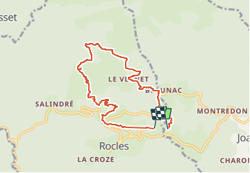

Length
8.3 km

Max alt
674 m

Uphill gradient
331 m
Km-Effort
12.7 km

Min alt
416 m

Downhill gradient
334 m
Boucle
No
Creation date :
2023-05-20 15:05:46.657
Updated on :
2023-05-20 17:05:32.933
1h57
Difficulty : Medium

FREE GPS app for hiking
 SityTrail
IGN / Geographical institutes
SityTrail Plus
The world is yours!
About
Trail Walking of 8.3 km to be discovered at Auvergne-Rhône-Alpes, Ardèche, Rocles. This trail is proposed by m.rozeron.
Positioning
Country:
France
Region :
Auvergne-Rhône-Alpes
Department/Province :
Ardèche
Municipality :
Rocles
Location:
Unknown
Start:(Dec)
Start:(UTM)
597402 ; 4935542 (31T) N.
Comments