


2023-05-21_18h00m05_De_Lentilleres_a_Chalancon

Linerou
User
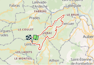

Length
14.2 km

Max alt
592 m

Uphill gradient
434 m
Km-Effort
20 km

Min alt
421 m

Downhill gradient
437 m
Boucle
Yes
Creation date :
2023-05-21 16:00:05.676
Updated on :
2023-12-31 10:29:28.869
4h32
Difficulty : Very difficult

FREE GPS app for hiking
 SityTrail
IGN / Geographical institutes
SityTrail Plus
The world is yours!
About
Trail Walking of 14.2 km to be discovered at Auvergne-Rhône-Alpes, Ardèche, Lentillères. This trail is proposed by Linerou.
Positioning
Country:
France
Region :
Auvergne-Rhône-Alpes
Department/Province :
Ardèche
Municipality :
Lentillères
Location:
Unknown
Start:(Dec)
Start:(UTM)
604186 ; 4940927 (31T) N.
Comments