


Passerelle Himalayenne

d.rognon
User
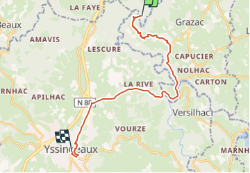

Length
12.5 km

Max alt
879 m

Uphill gradient
398 m
Km-Effort
17.2 km

Min alt
622 m

Downhill gradient
207 m
Boucle
No
Creation date :
2023-05-06 14:31:30.249
Updated on :
2023-05-22 06:55:20.09
13h26
Difficulty : Very easy

FREE GPS app for hiking
 SityTrail
IGN / Geographical institutes
SityTrail Plus
The world is yours!
About
Trail Walking of 12.5 km to be discovered at Auvergne-Rhône-Alpes, Haute-Loire, Saint-Maurice-de-Lignon. This trail is proposed by d.rognon.
Positioning
Country:
France
Region :
Auvergne-Rhône-Alpes
Department/Province :
Haute-Loire
Municipality :
Saint-Maurice-de-Lignon
Location:
Unknown
Start:(Dec)
Start:(UTM)
591104 ; 5004730 (31T) N.
Comments