


De La Mauldre à la Seine

jpcccb
User
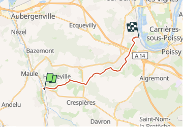

Length
14 km

Max alt
190 m

Uphill gradient
244 m
Km-Effort
17.3 km

Min alt
25 m

Downhill gradient
265 m
Boucle
No
Creation date :
2023-05-22 11:11:28.647
Updated on :
2023-05-22 11:19:53.509
3h56
Difficulty : Difficult

FREE GPS app for hiking
 SityTrail
IGN / Geographical institutes
SityTrail Plus
The world is yours!
About
Trail Walking of 14 km to be discovered at Ile-de-France, Yvelines, Mareil-sur-Mauldre. This trail is proposed by jpcccb.
Positioning
Country:
France
Region :
Ile-de-France
Department/Province :
Yvelines
Municipality :
Mareil-sur-Mauldre
Location:
Unknown
Start:(Dec)
Start:(UTM)
417269 ; 5416237 (31U) N.
Comments