


Chars

jpcccb
User
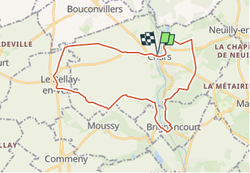

Length
13.7 km

Max alt
117 m

Uphill gradient
126 m
Km-Effort
15.3 km

Min alt
57 m

Downhill gradient
127 m
Boucle
Yes
Creation date :
2023-05-22 12:09:38.885
Updated on :
2024-10-03 09:15:13.594
3h29
Difficulty : Difficult

FREE GPS app for hiking
 SityTrail
IGN / Geographical institutes
SityTrail Plus
The world is yours!
About
Trail Walking of 13.7 km to be discovered at Ile-de-France, Val-d'Oise, Chars. This trail is proposed by jpcccb.
Positioning
Country:
France
Region :
Ile-de-France
Department/Province :
Val-d'Oise
Municipality :
Chars
Location:
Unknown
Start:(Dec)
Start:(UTM)
422474 ; 5446071 (31U) N.
Comments