


De Pontoise à Valmondois

jpcccb
User
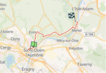

Length
14.9 km

Max alt
98 m

Uphill gradient
230 m
Km-Effort
17.9 km

Min alt
21 m

Downhill gradient
234 m
Boucle
No
Creation date :
2023-05-22 12:40:44.318
Updated on :
2023-05-22 12:48:00.606
4h04
Difficulty : Difficult

FREE GPS app for hiking
 SityTrail
IGN / Geographical institutes
SityTrail Plus
The world is yours!
About
Trail Walking of 14.9 km to be discovered at Ile-de-France, Val-d'Oise, Pontoise. This trail is proposed by jpcccb.
Positioning
Country:
France
Region :
Ile-de-France
Department/Province :
Val-d'Oise
Municipality :
Pontoise
Location:
Unknown
Start:(Dec)
Start:(UTM)
433926 ; 5433104 (31U) N.
Comments