


Boucle Rives de Yerres - Crosne - bois de la Grange - Réveillon

jeanmarcMasson
User GUIDE
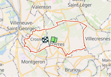

Length
16.6 km

Max alt
117 m

Uphill gradient
162 m
Km-Effort
18.8 km

Min alt
31 m

Downhill gradient
162 m
Boucle
Yes
Creation date :
2023-05-22 13:21:40.731
Updated on :
2023-05-22 13:23:04.987
4h16
Difficulty : Difficult

FREE GPS app for hiking
 SityTrail
IGN / Geographical institutes
SityTrail Plus
The world is yours!
About
Trail Walking of 16.6 km to be discovered at Ile-de-France, Essonne, Yerres. This trail is proposed by jeanmarcMasson.
Positioning
Country:
France
Region :
Ile-de-France
Department/Province :
Essonne
Municipality :
Yerres
Location:
Unknown
Start:(Dec)
Start:(UTM)
461675 ; 5395905 (31U) N.
Comments