


Corbeil cerf

Djaie60
User
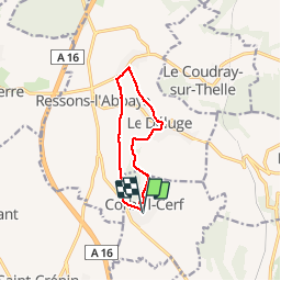

Length
9.3 km

Max alt
215 m

Uphill gradient
98 m
Km-Effort
10.6 km

Min alt
159 m

Downhill gradient
97 m
Boucle
Yes
Creation date :
2019-04-12 07:41:51.361
Updated on :
2019-04-12 07:41:51.424
2h13
Difficulty : Easy

FREE GPS app for hiking
 SityTrail
IGN / Geographical institutes
SityTrail Plus
The world is yours!
About
Trail Walking of 9.3 km to be discovered at Hauts-de-France, Oise, Corbeil-Cerf. This trail is proposed by Djaie60.
Positioning
Country:
France
Region :
Hauts-de-France
Department/Province :
Oise
Municipality :
Corbeil-Cerf
Location:
Unknown
Start:(Dec)
Start:(UTM)
434801 ; 5458834 (31U) N.
Comments