


Champagne Chateau de Chambly

avdem
User
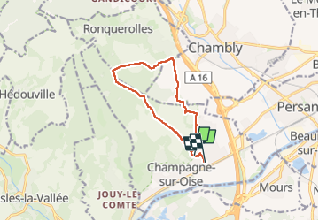

Length
9.8 km

Max alt
168 m

Uphill gradient
202 m
Km-Effort
12.5 km

Min alt
29 m

Downhill gradient
231 m
Boucle
No
Creation date :
2023-05-23 07:14:21.663
Updated on :
2023-05-23 09:57:53.628
2h42
Difficulty : Very easy

FREE GPS app for hiking
 SityTrail
IGN / Geographical institutes
SityTrail Plus
The world is yours!
About
Trail Walking of 9.8 km to be discovered at Ile-de-France, Val-d'Oise, Champagne-sur-Oise. This trail is proposed by avdem.
Description
bien
Positioning
Country:
France
Region :
Ile-de-France
Department/Province :
Val-d'Oise
Municipality :
Champagne-sur-Oise
Location:
Unknown
Start:(Dec)
Start:(UTM)
444300 ; 5443176 (31U) N.
Comments