


Majorque marnamara les plage

yves62410
User
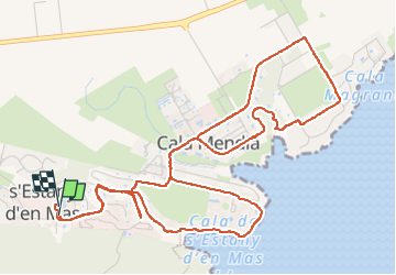

Length
8 km

Max alt
49 m

Uphill gradient
157 m
Km-Effort
10.1 km

Min alt
1 m

Downhill gradient
156 m
Boucle
Yes
Creation date :
2023-05-23 11:46:26.0
Updated on :
2023-05-23 14:45:10.141
2h58
Difficulty : Easy

FREE GPS app for hiking
 SityTrail
IGN / Geographical institutes
SityTrail Plus
The world is yours!
About
Trail Walking of 8 km to be discovered at Balearic Islands, Unknown, Manacor. This trail is proposed by yves62410.
Positioning
Country:
Spain
Region :
Balearic Islands
Department/Province :
Unknown
Municipality :
Manacor
Location:
Unknown
Start:(Dec)
Start:(UTM)
525853 ; 4374292 (31S) N.
Comments