


2023-05-24_21h23m02_L190128 SdF montée

avdem
User
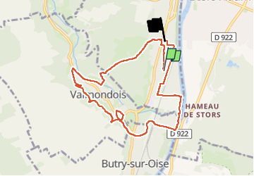

Length
8.9 km

Max alt
103 m

Uphill gradient
190 m
Km-Effort
11.4 km

Min alt
23 m

Downhill gradient
188 m
Boucle
No
Creation date :
2023-05-24 19:23:05.606
Updated on :
2023-05-24 19:23:07.279

FREE GPS app for hiking
 SityTrail
IGN / Geographical institutes
SityTrail Plus
The world is yours!
About
Trail of 8.9 km to be discovered at Ile-de-France, Val-d'Oise, Parmain. This trail is proposed by avdem.
Positioning
Country:
France
Region :
Ile-de-France
Department/Province :
Val-d'Oise
Municipality :
Parmain
Location:
Unknown
Start:(Dec)
Start:(UTM)
441974 ; 5438944 (31U) N.
Comments