


A

raygautier
User

Length
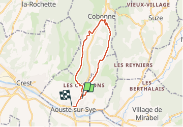
11.7 km

Max alt
427 m

Uphill gradient
288 m
Km-Effort
15.6 km

Min alt
209 m

Downhill gradient
292 m
Boucle
No
Creation date :
2023-05-25 06:15:49.0
Updated on :
2023-05-25 09:00:38.717
2h44
Difficulty : Difficult

FREE GPS app for hiking
 SityTrail
IGN / Geographical institutes
SityTrail Plus
The world is yours!
About
Trail Walking of 11.7 km to be discovered at Auvergne-Rhône-Alpes, Drôme, Aouste-sur-Sye. This trail is proposed by raygautier.
Positioning
Country:
France
Region :
Auvergne-Rhône-Alpes
Department/Province :
Drôme
Municipality :
Aouste-sur-Sye
Location:
Unknown
Start:(Dec)
Start:(UTM)
663370 ; 4953989 (31T) N.
Comments