


jour de bis

Francinedu
User
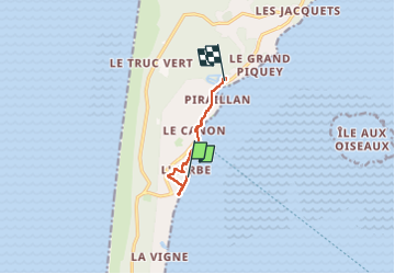

Length
5.5 km

Max alt
29 m

Uphill gradient
66 m
Km-Effort
6.4 km

Min alt
2 m

Downhill gradient
62 m
Boucle
No
Creation date :
2023-05-25 12:49:45.529
Updated on :
2023-05-25 14:25:02.359
1h34
Difficulty : Medium

FREE GPS app for hiking
 SityTrail
IGN / Geographical institutes
SityTrail Plus
The world is yours!
About
Trail Walking of 5.5 km to be discovered at New Aquitaine, Gironde, Lège-Cap-Ferret. This trail is proposed by Francinedu.
Positioning
Country:
France
Region :
New Aquitaine
Department/Province :
Gironde
Municipality :
Lège-Cap-Ferret
Location:
Unknown
Start:(Dec)
Start:(UTM)
640065 ; 4950048 (30T) N.
Comments