


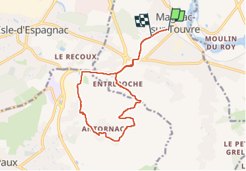
La balade d'Antornac

alainjoseph6
User

Length
8.1 km

Max alt
133 m

Uphill gradient
125 m
Km-Effort
9.7 km

Min alt
58 m

Downhill gradient
113 m
Boucle
No
Creation date :
2023-05-25 11:51:02.492
Updated on :
2023-05-25 15:41:52.185
3h50
Difficulty : Medium

FREE GPS app for hiking
 SityTrail
IGN / Geographical institutes
SityTrail Plus
The world is yours!
About
Trail Walking of 8.1 km to be discovered at New Aquitaine, Charente, Magnac-sur-Touvre. This trail is proposed by alainjoseph6.
Description
une superbe randonnée au départ de Du haut de Magnac sur Touvre
Photos


Positioning
Country:
France
Region :
New Aquitaine
Department/Province :
Charente
Municipality :
Magnac-sur-Touvre
Location:
Unknown
Start:(Dec)
Start:(UTM)
284628 ; 5060496 (31T) N.
Comments