


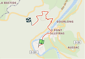
balade en J'ai vos dents

CDSM 55
User

Length
2.6 km

Max alt
832 m

Uphill gradient
186 m
Km-Effort
4.5 km

Min alt
654 m

Downhill gradient
25 m
Boucle
No
Creation date :
2023-05-26 07:57:21.782
Updated on :
2023-05-26 10:26:43.745
44m
Difficulty : Easy

FREE GPS app for hiking
 SityTrail
IGN / Geographical institutes
SityTrail Plus
The world is yours!
About
Trail Walking of 2.6 km to be discovered at Auvergne-Rhône-Alpes, Haute-Loire, Alleyras. This trail is proposed by CDSM 55.
Photos


Positioning
Country:
France
Region :
Auvergne-Rhône-Alpes
Department/Province :
Haute-Loire
Municipality :
Alleyras
Location:
Unknown
Start:(Dec)
Start:(UTM)
552707 ; 4973716 (31T) N.
Comments
dommage, l'enregistrement du retour n'a pas fonctionné