


villefort

Bonet
User
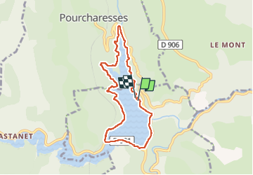

Length
7.7 km

Max alt
650 m

Uphill gradient
178 m
Km-Effort
10 km

Min alt
576 m

Downhill gradient
174 m
Boucle
Yes
Creation date :
2023-05-26 11:26:32.073
Updated on :
2023-05-26 13:31:08.413
2h03
Difficulty : Medium

FREE GPS app for hiking
 SityTrail
IGN / Geographical institutes
SityTrail Plus
The world is yours!
About
Trail Walking of 7.7 km to be discovered at Occitania, Lozère, Villefort. This trail is proposed by Bonet.
Description
tour du lac de villefort ,
Positioning
Country:
France
Region :
Occitania
Department/Province :
Lozère
Municipality :
Villefort
Location:
Unknown
Start:(Dec)
Start:(UTM)
573885 ; 4923096 (31T) N.
Comments