


R1T-A52S-Bièvres

Jack-94
User
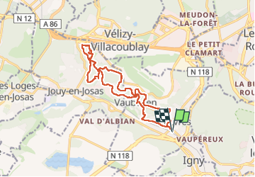

Length
16 km

Max alt
185 m

Uphill gradient
336 m
Km-Effort
20 km

Min alt
74 m

Downhill gradient
335 m
Boucle
Yes
Creation date :
2023-05-26 07:48:45.794
Updated on :
2023-05-28 14:17:57.427
4h39
Difficulty : Very difficult

FREE GPS app for hiking
 SityTrail
IGN / Geographical institutes
SityTrail Plus
The world is yours!
About
Trail Walking of 16 km to be discovered at Ile-de-France, Essonne, Bièvres. This trail is proposed by Jack-94.

Positioning
Country:
France
Region :
Ile-de-France
Department/Province :
Essonne
Municipality :
Bièvres
Location:
Unknown
Start:(Dec)
Start:(UTM)
442343 ; 5400124 (31U) N.
Comments