


buggenhout bos

Peter.vdbergh
User GUIDE
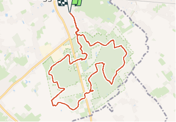

Length
10.7 km

Max alt
38 m

Uphill gradient
92 m
Km-Effort
12 km

Min alt
8 m

Downhill gradient
92 m
Boucle
Yes
Creation date :
2023-05-14 12:04:56.832
Updated on :
2023-05-28 07:57:18.026
2h35
Difficulty : Easy

FREE GPS app for hiking
 SityTrail
IGN / Geographical institutes
SityTrail Plus
The world is yours!
About
Trail Walking of 10.7 km to be discovered at Flanders, East Flanders, Buggenhout. This trail is proposed by Peter.vdbergh.
Positioning
Country:
Belgium
Region :
Flanders
Department/Province :
East Flanders
Municipality :
Buggenhout
Location:
Buggenhout
Start:(Dec)
Start:(UTM)
584699 ; 5651832 (31U) N.
Comments