


randonnée Serriera

René Strouwen
User
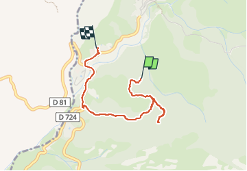

Length
3.2 km

Max alt
220 m

Uphill gradient
114 m
Km-Effort
5 km

Min alt
26 m

Downhill gradient
196 m
Boucle
No
Creation date :
2023-05-28 09:08:25.115
Updated on :
2023-05-28 10:45:10.342
2h35
Difficulty : Easy

FREE GPS app for hiking
 SityTrail
IGN / Geographical institutes
SityTrail Plus
The world is yours!
About
Trail Walking of 3.2 km to be discovered at Corsica, South Corsica, Serriera. This trail is proposed by René Strouwen.
Description
Randonnée ombragée apres grande air de battage à droite
Positioning
Country:
France
Region :
Corsica
Department/Province :
South Corsica
Municipality :
Serriera
Location:
Unknown
Start:(Dec)
Start:(UTM)
475893 ; 4682437 (32T) N.
Comments