


UHRWILLER Ernolsheim

Rémy Isenmann
User
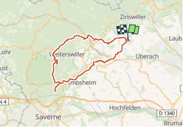

Length
56 km

Max alt
379 m

Uphill gradient
898 m
Km-Effort
68 km

Min alt
174 m

Downhill gradient
894 m
Boucle
No
Creation date :
2023-05-28 05:03:04.421
Updated on :
2023-05-28 19:30:56.771
6h22
Difficulty : Medium

FREE GPS app for hiking
 SityTrail
IGN / Geographical institutes
SityTrail Plus
The world is yours!
About
Trail Coupling of 56 km to be discovered at Grand Est, Bas-Rhin, Uhrwiller. This trail is proposed by Rémy Isenmann.
Positioning
Country:
France
Region :
Grand Est
Department/Province :
Bas-Rhin
Municipality :
Uhrwiller
Location:
Unknown
Start:(Dec)
Start:(UTM)
395447 ; 5414802 (32U) N.
Comments