


A+ St Erblon

nolsim
User
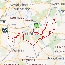

Length
14.2 km

Max alt
52 m

Uphill gradient
108 m
Km-Effort
15.7 km

Min alt
23 m

Downhill gradient
100 m
Boucle
No
Creation date :
2018-08-18 14:09:42.966
Updated on :
2018-08-18 14:09:42.966
3h01
Difficulty : Easy

FREE GPS app for hiking
 SityTrail
IGN / Geographical institutes
SityTrail Plus
The world is yours!
About
Trail Walking of 14.2 km to be discovered at Brittany, Ille-et-Vilaine, Saint-Erblon. This trail is proposed by nolsim.
Positioning
Country:
France
Region :
Brittany
Department/Province :
Ille-et-Vilaine
Municipality :
Saint-Erblon
Location:
Unknown
Start:(Dec)
Start:(UTM)
600890 ; 5319428 (30U) N.
Comments