


Lac bleu

raygautier
User
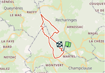

Length
12.6 km

Max alt
1423 m

Uphill gradient
379 m
Km-Effort
17.7 km

Min alt
1215 m

Downhill gradient
377 m
Boucle
Yes
Creation date :
2023-05-29 07:26:26.0
Updated on :
2023-05-29 11:33:37.344
4h06
Difficulty : Difficult

FREE GPS app for hiking
 SityTrail
IGN / Geographical institutes
SityTrail Plus
The world is yours!
About
Trail Walking of 12.6 km to be discovered at Auvergne-Rhône-Alpes, Haute-Loire, Champclause. This trail is proposed by raygautier.
Positioning
Country:
France
Region :
Auvergne-Rhône-Alpes
Department/Province :
Haute-Loire
Municipality :
Champclause
Location:
Unknown
Start:(Dec)
Start:(UTM)
591161 ; 4987694 (31T) N.
Comments