


niderviller

Titinechris
User
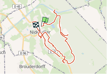

Length
12.8 km

Max alt
337 m

Uphill gradient
184 m
Km-Effort
15.2 km

Min alt
259 m

Downhill gradient
184 m
Boucle
No
Creation date :
2023-05-29 07:11:01.12
Updated on :
2023-05-29 12:20:51.18
5h08
Difficulty : Difficult

FREE GPS app for hiking
 SityTrail
IGN / Geographical institutes
SityTrail Plus
The world is yours!
About
Trail Walking of 12.8 km to be discovered at Grand Est, Moselle, Niderviller. This trail is proposed by Titinechris.
Positioning
Country:
France
Region :
Grand Est
Department/Province :
Moselle
Municipality :
Niderviller
Location:
Unknown
Start:(Dec)
Start:(UTM)
360839 ; 5397421 (32U) N.
Comments