


cross_izzie

fredodlageo
User
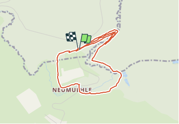

Length
4.9 km

Max alt
272 m

Uphill gradient
116 m
Km-Effort
6.4 km

Min alt
234 m

Downhill gradient
113 m
Boucle
Yes
Creation date :
2014-12-10 00:00:00.0
Updated on :
2014-12-10 00:00:00.0
32m
Difficulty : Medium

FREE GPS app for hiking
 SityTrail
IGN / Geographical institutes
SityTrail Plus
The world is yours!
About
Trail Running of 4.9 km to be discovered at Grand Est, Bas-Rhin, Diemeringen. This trail is proposed by fredodlageo.
Description
20141207
Positioning
Country:
France
Region :
Grand Est
Department/Province :
Bas-Rhin
Municipality :
Diemeringen
Location:
Unknown
Start:(Dec)
Start:(UTM)
370048 ; 5422195 (32U) N.
Comments