


Draveil

JLKino
User

Length
13.6 km

Max alt
73 m

Uphill gradient
136 m
Km-Effort
15.4 km

Min alt
30 m

Downhill gradient
138 m
Boucle
No
Creation date :
2023-05-30 07:31:16.932
Updated on :
2023-05-30 12:40:48.331
5h10
Difficulty : Difficult

FREE GPS app for hiking
 SityTrail
IGN / Geographical institutes
SityTrail Plus
The world is yours!
About
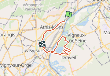
Trail Walking of 13.6 km to be discovered at Ile-de-France, Essonne, Athis-Mons. This trail is proposed by JLKino.
Positioning
Country:
France
Region :
Ile-de-France
Department/Province :
Essonne
Municipality :
Athis-Mons
Location:
Unknown
Start:(Dec)
Start:(UTM)
456130 ; 5395654 (31U) N.
Comments