


Quinson

fab4u
User
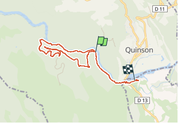

Length
8.6 km

Max alt
543 m

Uphill gradient
308 m
Km-Effort
12.8 km

Min alt
357 m

Downhill gradient
339 m
Boucle
No
Creation date :
2023-04-16 10:00:33.824
Updated on :
2023-05-31 17:19:30.195
4h31
Difficulty : Medium

FREE GPS app for hiking
 SityTrail
IGN / Geographical institutes
SityTrail Plus
The world is yours!
About
Trail Walking of 8.6 km to be discovered at Provence-Alpes-Côte d'Azur, Alpes-de-Haute-Provence, Quinson. This trail is proposed by fab4u.
Positioning
Country:
France
Region :
Provence-Alpes-Côte d'Azur
Department/Province :
Alpes-de-Haute-Provence
Municipality :
Quinson
Location:
Unknown
Start:(Dec)
Start:(UTM)
260260 ; 4843006 (32T) N.
Comments