


Le marais de Bonnefond

Gegetop
User

Length
2.1 km

Max alt
339 m

Uphill gradient
20 m
Km-Effort
2.3 km

Min alt
321 m

Downhill gradient
20 m
Boucle
Yes
Creation date :
2023-06-01 12:28:38.529
Updated on :
2023-06-01 13:37:44.648
1h07
Difficulty : Easy

FREE GPS app for hiking
 SityTrail
IGN / Geographical institutes
SityTrail Plus
The world is yours!
About
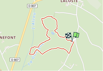
Trail Walking of 2.1 km to be discovered at Occitania, Lot, Mayrinhac-Lentour. This trail is proposed by Gegetop.
Description
Petit circuit aménagé qui vous fera découvrir la vie dans les milieux humides.
Photos


Positioning
Country:
France
Region :
Occitania
Department/Province :
Lot
Municipality :
Mayrinhac-Lentour
Location:
Unknown
Start:(Dec)
Start:(UTM)
405038 ; 4963636 (31T) N.
Comments