Trail Walking Chiroubles - Col du Fût d’Avenas (18 km - D. 554 m) - Photo

Col du Fût d’Avenas (18 km - D. 554 m)

© OpenStreetMap contributors
Length
Length
17.7 km
Max alt
Max alt
887 m
Uphill gradient
Uphill gradient
554 m
Km-Effort
Km-Effort  
25 km
Min alt
Min alt
537 m
Downhill gradient
Downhill gradient
559 m
Boucle
Boucle
Yes
Creation date :
2023-06-01 06:58:20.0
Updated on :
2023-06-02 08:58:45.231

(0 Reviews)

Walking
Walking
5h41
Difficulty : Very difficult

Scan this QR Code to open this trail in the SityTrail application

FREE GPS app for hiking

Logo SityTrail SityTrail

IGN / Geographical institutes

Download SityTrail from the App Store Download SityTrail from Google Play

Logo SityTrail SityTrail World

The world is yours!

Download SityTrail from the App Store Download SityTrail from Google Play Download SityTrail on Huawei AppGallery

About

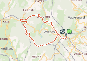
Trail Walking of 17.7 km to be discovered at Auvergne-Rhône-Alpes, Rhône, Chiroubles. This trail is proposed by Thomasdanielle.

Description

D/A : Parking en haut sur la droite après  le restaurant

Elevation profile

Positioning

Country:
France
Region :
Auvergne-Rhône-Alpes
Department/Province :
Rhône
Municipality :
Chiroubles
Location:
Unknown
Start:(UTM)
625702 ; 5116459 (31T) N.

Trails nearby

Trail Walking Deux-Grosnes - Ouroux - Photo
Walking
Galoche

Walking

Difficult
(1)
Deux-Grosnes, Auvergne-Rhône-Alpes, Rhône, France
19.1 km | 0 m-effort
5h 57min
Yes
Trail Mountain bike Lantignié - 19e Rando des Primeurs - Photo
Mountain bike
tracegps

Mountain bike

Difficult
(1)
Lantignié, Auvergne-Rhône-Alpes, Rhône, France
30 km | 45 km-effort
3h 0min
Yes
Trail Walking Vauxrenard - vauxrenard - Photo
Walking
Zeugma13

Walking

Difficult
(1)
Vauxrenard, Auvergne-Rhône-Alpes, Rhône, France
21 km | 31 km-effort
5h 7min
Yes
Trail Walking Vauxrenard - Itinérant Beaujolais rouge étape 6 Foretal - Macon gare TGV - Photo
Walking
chessyca

Walking

Very difficult
Vauxrenard, Auvergne-Rhône-Alpes, Rhône, France
23 km | 28 km-effort
6h 26min
No
Trail Walking Chiroubles - Itinérant Beaujolais rouge étape 5 Chiroubles- Foretal - Photo
Walking
chessyca

Walking

Medium
Chiroubles, Auvergne-Rhône-Alpes, Rhône, France
23 km | 32 km-effort
5h 44min
No
Trail Walking Beaujeu - Itinérant Beaujolais rouge étape 4 . Malval - Chiroubles - Photo
Walking
chessyca

Walking

Medium
Beaujeu, Auvergne-Rhône-Alpes, Rhône, France
26 km | 34 km-effort
5h 40min
No
Trail Walking Chiroubles - 2023-05-26_00h30m21_28127-15675317-2 (2) - Photo
Walking
daniellebou

Walking

Very difficult
(1)
Chiroubles, Auvergne-Rhône-Alpes, Rhône, France
16.9 km | 26 km-effort
5h 49min
Yes
Trail On foot Deux-Grosnes - Circuit des Sapins - Photo
On foot
PRO

On foot

Difficult
Deux-Grosnes, Auvergne-Rhône-Alpes, Rhône, France
22 km | 33 km-effort
7h 34min
Yes
Trail Walking Deux-Grosnes - Séjour RCY : Les crêtes du Haut Beaujolais journée 3 - Photo
Walking
chessyca

Walking

Very difficult
Deux-Grosnes, Auvergne-Rhône-Alpes, Rhône, France
22 km | 32 km-effort
5h 42min
No


Close
My subscriptions