


Barnabé Haybes

Tommy Eric
User
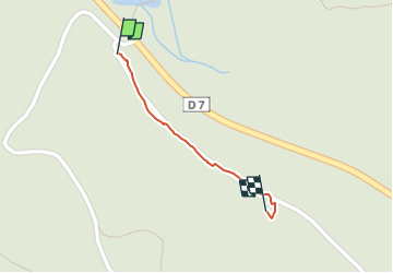

Length
369 m

Max alt
190 m

Uphill gradient
33 m
Km-Effort
699 m

Min alt
147 m

Downhill gradient
0 m
Boucle
No
Creation date :
2023-05-23 13:59:49.091
Updated on :
2023-06-02 14:15:17.283
8m
Difficulty : Easy

FREE GPS app for hiking
 SityTrail
IGN / Geographical institutes
SityTrail Plus
The world is yours!
About
Trail Walking of 369 m to be discovered at Grand Est, Ardennes, Haybes. This trail is proposed by Tommy Eric.
Positioning
Country:
France
Region :
Grand Est
Department/Province :
Ardennes
Municipality :
Haybes
Location:
Unknown
Start:(Dec)
Start:(UTM)
623680 ; 5541118 (31U) N.
Comments