


Mont Clocher

whisper73
User
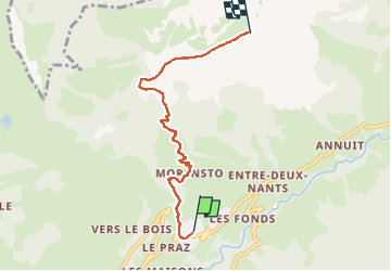

Length
5.1 km

Max alt
1962 m

Uphill gradient
803 m
Km-Effort
13.1 km

Min alt
1153 m

Downhill gradient
0 m
Boucle
No
Creation date :
2023-06-03 05:22:56.942
Updated on :
2023-06-03 07:10:49.982
1h43
Difficulty : Difficult
20m
Difficulty : Very easy

FREE GPS app for hiking
 SityTrail
IGN / Geographical institutes
SityTrail Plus
The world is yours!
About
Trail Walking of 5.1 km to be discovered at Auvergne-Rhône-Alpes, Savoy, Hauteluce. This trail is proposed by whisper73.
Positioning
Country:
France
Region :
Auvergne-Rhône-Alpes
Department/Province :
Savoy
Municipality :
Hauteluce
Location:
Unknown
Start:(Dec)
Start:(UTM)
311904 ; 5069052 (32T) N.
Comments