


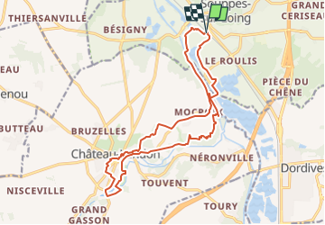
Autour de Château Landon

jpcccb
User

Length
17.1 km

Max alt
111 m

Uphill gradient
218 m
Km-Effort
20 km

Min alt
60 m

Downhill gradient
218 m
Boucle
Yes
Creation date :
2023-06-03 13:31:58.647
Updated on :
2024-06-24 09:16:45.94
4h33
Difficulty : Very difficult

FREE GPS app for hiking
 SityTrail
IGN / Geographical institutes
SityTrail Plus
The world is yours!
About
Trail Walking of 17.1 km to be discovered at Ile-de-France, Seine-et-Marne, Souppes-sur-Loing. This trail is proposed by jpcccb.

Positioning
Country:
France
Region :
Ile-de-France
Department/Province :
Seine-et-Marne
Municipality :
Souppes-sur-Loing
Location:
Unknown
Start:(Dec)
Start:(UTM)
480331 ; 5336494 (31U) N.
Comments