


Rando des Lacs-Badonviller-4 juin 2023

nicolas54230
User
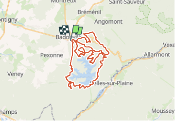

Length
40 km

Max alt
510 m

Uphill gradient
958 m
Km-Effort
53 km

Min alt
312 m

Downhill gradient
959 m
Boucle
Yes
Creation date :
2023-06-03 13:41:52.196
Updated on :
2023-06-03 13:42:59.679
3h38
Difficulty : Very difficult

FREE GPS app for hiking
 SityTrail
IGN / Geographical institutes
SityTrail Plus
The world is yours!
About
Trail Mountain bike of 40 km to be discovered at Grand Est, Meurthe-et-Moselle, Badonviller. This trail is proposed by nicolas54230.
Positioning
Country:
France
Region :
Grand Est
Department/Province :
Meurthe-et-Moselle
Municipality :
Badonviller
Location:
Unknown
Start:(Dec)
Start:(UTM)
344368 ; 5373636 (32U) N.
Comments