


Sermaise

pascal.dabet
User
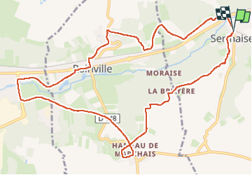

Length
12.4 km

Max alt
159 m

Uphill gradient
204 m
Km-Effort
15.1 km

Min alt
79 m

Downhill gradient
202 m
Boucle
Yes
Creation date :
2023-06-04 12:09:11.723
Updated on :
2023-06-04 15:48:36.583
3h38
Difficulty : Difficult

FREE GPS app for hiking
 SityTrail
IGN / Geographical institutes
SityTrail Plus
The world is yours!
About
Trail Walking of 12.4 km to be discovered at Ile-de-France, Essonne, Sermaise. This trail is proposed by pascal.dabet.
Positioning
Country:
France
Region :
Ile-de-France
Department/Province :
Essonne
Municipality :
Sermaise
Location:
Unknown
Start:(Dec)
Start:(UTM)
432165 ; 5376409 (31U) N.
Comments