


Bouillon Ramonette Corbion Rocher du pendu

ramagufa
User
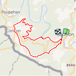

Length
15.9 km

Max alt
442 m

Uphill gradient
483 m
Km-Effort
22 km

Min alt
211 m

Downhill gradient
484 m
Boucle
Yes
Creation date :
2019-04-16 19:16:51.175
Updated on :
2019-04-16 19:16:51.21
4h38
Difficulty : Medium

FREE GPS app for hiking
 SityTrail
IGN / Geographical institutes
SityTrail Plus
The world is yours!
About
Trail Walking of 15.9 km to be discovered at Wallonia, Luxembourg, Bouillon. This trail is proposed by ramagufa.
Description
Départ du tunnel de Bouillon sur la route vers Corbion et prendre le sentier à Gauche vers la Ramonette
Positioning
Country:
Belgium
Region :
Wallonia
Department/Province :
Luxembourg
Municipality :
Bouillon
Location:
Bouillon
Start:(Dec)
Start:(UTM)
648499 ; 5517532 (31U) N.
Comments