


Col de Bratte

PhilippeC54
User
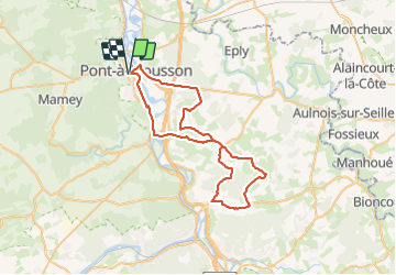

Length
52 km

Max alt
397 m

Uphill gradient
702 m
Km-Effort
62 km

Min alt
176 m

Downhill gradient
702 m
Boucle
Yes
Creation date :
2023-06-05 13:11:06.97
Updated on :
2023-06-05 16:21:52.153
2h21
Difficulty : Medium

FREE GPS app for hiking
 SityTrail
IGN / Geographical institutes
SityTrail Plus
The world is yours!
About
Trail Road bike of 52 km to be discovered at Grand Est, Meurthe-et-Moselle, Pont-à-Mousson. This trail is proposed by PhilippeC54.
Positioning
Country:
France
Region :
Grand Est
Department/Province :
Meurthe-et-Moselle
Municipality :
Pont-à-Mousson
Location:
Unknown
Start:(Dec)
Start:(UTM)
283578 ; 5420458 (32U) N.
Comments