


digne

CABERMAT
User
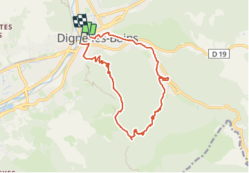

Length
9.4 km

Max alt
992 m

Uphill gradient
423 m
Km-Effort
15 km

Min alt
592 m

Downhill gradient
415 m
Boucle
No
Creation date :
2023-06-07 07:04:26.312
Updated on :
2023-06-07 11:54:45.654
4h49
Difficulty : Difficult

FREE GPS app for hiking
 SityTrail
IGN / Geographical institutes
SityTrail Plus
The world is yours!
About
Trail Walking of 9.4 km to be discovered at Provence-Alpes-Côte d'Azur, Alpes-de-Haute-Provence, Digne-les-Bains. This trail is proposed by CABERMAT.
Positioning
Country:
France
Region :
Provence-Alpes-Côte d'Azur
Department/Province :
Alpes-de-Haute-Provence
Municipality :
Digne-les-Bains
Location:
Unknown
Start:(Dec)
Start:(UTM)
278318 ; 4885667 (32T) N.
Comments