


blaireaux partie circuit vtt + nage

Titinechris
User
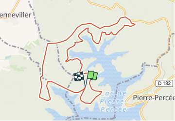

Length
12.2 km

Max alt
441 m

Uphill gradient
231 m
Km-Effort
15.3 km

Min alt
390 m

Downhill gradient
231 m
Boucle
Yes
Creation date :
2023-06-10 05:46:25.702
Updated on :
2023-06-10 05:47:29.176
0m
Difficulty : Easy

FREE GPS app for hiking
 SityTrail
IGN / Geographical institutes
SityTrail Plus
The world is yours!
About
Trail Trail of 12.2 km to be discovered at Grand Est, Meurthe-et-Moselle, Badonviller. This trail is proposed by Titinechris.
Positioning
Country:
France
Region :
Grand Est
Department/Province :
Meurthe-et-Moselle
Municipality :
Badonviller
Location:
Unknown
Start:(Dec)
Start:(UTM)
345395 ; 5370770 (32U) N.
Comments