


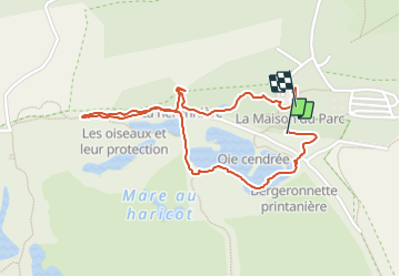
Circuit Marquenterre

d.rognon
User

Length
2 km

Max alt
16 m

Uphill gradient
12 m
Km-Effort
2.1 km

Min alt
4 m

Downhill gradient
8 m
Boucle
Yes
Creation date :
2023-06-13 07:41:14.122
Updated on :
2023-06-13 10:43:03.972
2h01
Difficulty : Easy

FREE GPS app for hiking
 SityTrail
IGN / Geographical institutes
SityTrail Plus
The world is yours!
About
Trail Walking of 2 km to be discovered at Hauts-de-France, Somme, Saint-Quentin-en-Tourmont. This trail is proposed by d.rognon.
Positioning
Country:
France
Region :
Hauts-de-France
Department/Province :
Somme
Municipality :
Saint-Quentin-en-Tourmont
Location:
Unknown
Start:(Dec)
Start:(UTM)
399191 ; 5568811 (31U) N.
Comments